Back تيار كوروشيو Arabic Kurosio cərəyanı AZ Курасіа (цячэнне) BE কুরোশিও স্রোত Bengali/Bangla Corrent de Kuroshio Catalan Kurošio Czech Kuroshio German Κουροσίβο Greek Kuroŝivo EO Corriente de Kuroshio Spanish
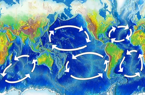
The Kuroshio Current (黒潮, "Black Tide"), also known as the Black Current or Japan Current (日本海流, Nihon Kairyū) is a north-flowing, warm ocean current on the west side of the North Pacific Ocean basin. It was named for the deep blue appearance of its waters. Similar to the Gulf Stream in the North Atlantic, the Kuroshio is a powerful western boundary current that transports warm equatorial water poleward and forms the western limb of the North Pacific Subtropical Gyre. Off the East Coast of Japan, it merges with the Oyashio Current to form the North Pacific Current.
The Kuroshio Current has significant effects on both physical and biological processes of the North Pacific Ocean, including nutrient and sediment transport, major pacific storm tracks and regional climate, and Pacific mode water formation.[1][2][3] Additionally, the current's significant nutrient transport results in a biologically rich ecoregion supporting an important fishing industry as well as diverse marine food webs. The South China Sea for example has relatively low nutrient concentrations in its upper waters, but experiences enhanced biological productivity due to the input from the Kuroshio Current Intrusion.[4] Ongoing research centered around the Kuroshio Current's response to climate change predicts a strengthening in surface flows of this western boundary current which contrasts the predicted changes in the Atlantic Ocean's Gulf Stream.[5]
- ^ Hu, Dunxin; Wu, Lixin; Cai, Wenju; Gupta, Alex Sen; Ganachaud, Alexandre; Qiu, Bo; Gordon, Arnold L.; Lin, Xiaopei; Chen, Zhaohui; Hu, Shijian; Wang, Guojian (2015). "Pacific western boundary currents and their roles in climate". Nature. 522 (7556): 299–308. Bibcode:2015Natur.522..299H. doi:10.1038/nature14504. ISSN 1476-4687. PMID 26085269. S2CID 4404216.
- ^ Das, Prabodha; Lin, Andrew Tien-Shun; Chen, Min-Pen Philip; Miramontes, Elda; Liu, Char-Shine; Huang, Neng-Wei; Kung, Jennifer; Hsu, Shu-Kun; Pillutla, Radha Krishna; Nayak, Kalyani (2021-05-20). "Deep-sea submarine erosion by the Kuroshio Current in the Manila accretionary prism, offshore Southern Taiwan". Tectonophysics. 807: 228813. Bibcode:2021Tectp.80728813D. doi:10.1016/j.tecto.2021.228813. ISSN 0040-1951. S2CID 233823458.
- ^ Terazaki, Makoto (1989) "Recent Large-Scale Changes in the Biomass of the Kuroshio Current Ecosystem" in Kenneth Sherman and Lewis M. Alexander (eds.), Biomass Yields and Geography of Large Marine Ecosystems (Boulder: Westview) AAAS Selected Symposium 111, pp. 37–65. ISBN 0-8133-7844-3
- ^ Du, C.; Liu, Z.; Dai, M.; Kao, S.-J.; Cao, Z.; Zhang, Y.; Huang, T.; Wang, L.; Li, Y. (2013). "Impact of the Kuroshio intrusion on the nutrient inventory in the upper northern South China Sea: Insights from an isopycnal mixing model". Biogeosciences. 10: 6939–6972. doi:10.5194/bgd-10-6939-2013.
- ^ Chen, Changlin; Wang, Guihua; Xie, Shang-Ping; Liu, Wei (2019-10-01). "Why Does Global Warming Weaken the Gulf Stream but Intensify the Kuroshio?". Journal of Climate. 32 (21): 7437–7451. Bibcode:2019JCli...32.7437C. doi:10.1175/jcli-d-18-0895.1. ISSN 0894-8755. S2CID 201330185.
