Back Salar de Arizaro CEB Salar de Arizaro Czech Salar de Arizaro Spanish Salar d'Arizaro French アリサロ塩原 Japanese სალარ-დე-არისარო KA Arisaro druskožemis LT Salar de Arizaro Polish Salar de Arizaro Swedish
| Salar de Arizaro | |
|---|---|
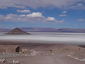
 A view of the Salar de Arizaro | |
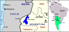
 Location of Salar de Arizaro (blue) within northwestern Argentina and South America | |
| Location | Argentina |
| Coordinates | 24°43′22.8″S 67°44′16.8″W / 24.723000°S 67.738000°W |
| Basin countries | Argentina |
| Max. length | 100 km (62 mi)[1] |
| Max. width | 50 km (31 mi)[1] |
| Surface area | 1,600 km2 (618 sq mi) |
| Surface elevation | 3,460 m (11,352 ft) |
| Islands | Cono de Arita |
| Settlements | Tolar Grande |

Salar de Arizaro ("Arizaro" comes from Atacameno haâri "crow", "condor" and ara, aro, "accommodation", "place where something is common".[3]) is a large salt flat of the Andes in north-western Argentina. It is located between the villages of Tolar Grande and Caipe and near Mina La Casualidad,[1] in Los Andes Department, Salta Province.
- ^ a b c (in Spanish) An article about the Salar de Arizaro Archived 2013-01-14 at archive.today
- ^ Salar de Arizaro at NASA Earth Observatory
- ^ Vaisse, Emilio F. (1 January 1895). "Glosario de la lengua atacameña". Anales de la Universidad de Chile (in Spanish): 533. doi:10.5354/anuc.v0i-.20911. ISSN 0717-8883.
