Back Bathurst-eiland AF Baterst (ada) AZ Батърст (остров) Bulgarian Illa de Bathurst Catalan Bathurst Island (pulo sa Kanada) CEB Bathurstův ostrov (Kanada) Czech Ynys Bathurst CY Bathurst Island (Kanada) German Νήσος Μπάθερστ Greek Isla de Bathurst (Canadá) Spanish
 NASA satellite photo montage of Bathurst Island at centre. Viscount Melville Sound, part of the Northwest Passage, adjoins it to the south. | |
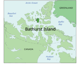
 Location of Bathurst Island | |
| Geography | |
|---|---|
| Location | Northern Canada |
| Coordinates | 75°46′N 099°47′W / 75.767°N 99.783°W |
| Archipelago | Queen Elizabeth Islands Arctic Archipelago |
| Area | 16,042 km2 (6,194 sq mi) |
| Area rank | 54th |
| Length | 117 mi (188 km) |
| Width | 63–94 mi (101–151 km) |
| Administration | |
Canada | |
| Territory | Nunavut |
| Demographics | |
| Population | 0 |
Bathurst Island is one of the Queen Elizabeth Islands in Nunavut, Canada. It is a member of the Arctic Archipelago. The area of the island is estimated at 16,042 km2 (6,194 sq mi),[1] 115 to 117 mi (185 to 188 km) long and from 63 mi (101 km) to 72 mi (116 km) to 92.9 mi (149.5 km) wide, making it Canada's 13th largest island. It is located between Devon Island and Cornwallis Island in the east, and Melville Island in the west. Four small islands of Cameron, Vanier, Massey and Alexander lie in its northwest.
The island is low-lying with few parts higher than 330 m (1,083 ft) in elevation. The highest point is 412 m (1,352 ft) at Stokes Mountain in the Stokes Range. This in turn forms part of the Arctic Cordillera mountain system. Good soil conditions produce abundant vegetation and support a more prolific wildlife population than other Arctic islands.
The island contains both the International Biological Program site Polar Bear Pass and Qausuittuq National Park.
- ^ "Atlas of Canada". Atlas.nrcan.gc.ca. 12 August 2009. Archived from the original on 22 January 2013. Retrieved 30 August 2010.

