Back Milpa Alta (munisipyo) CEB Milpa Alta German Milpa Alta Spanish Milpa Alta EU Milpa Alta French Milpa Alta GA Milpa Alta Hungarian Delegazione Milpa Alta Italian ミルパ・アルタ Japanese Milpa Alta LA
Milpa Alta | |
|---|---|
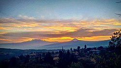
 Iztaccíhuatl (left) and Popocatépetl (right) from the community of San Bartolomé Xicomulco, Milpa Alta. | |
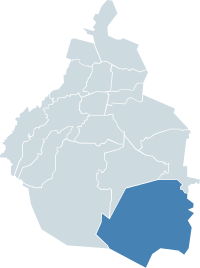
 Milpa Alta within Mexico City | |
| Country | Mexico |
| Federal entity | Mexico City |
| Established | 1903 |
| Named for | Monastic community |
| Seat | Av. México, esq. Constitución S/N Col. Villa Milpa Alta |
| Government | |
| • Jefe delegacional | Francisco García Flores (PRD) |
| Area | |
| • Total | 286.234 km2 (110.516 sq mi) |
| Population (2010)[2] | |
| • Total | 130,582 |
| • Density | 460/km2 (1,200/sq mi) |
| Time zone | UTC-6 (Central Standard Time) |
| • Summer (DST) | UTC-5 (Central Daylight Time) |
| Postal codes | 04000 – 04980 |
| Area code | 55 |
| Website | milpa-alta.cdmx.gob.mx |
Milpa Alta is a borough (demarcación territorial) in Mexico City. It lies in the southeast corner of the nation's capital, bordering the State of Mexico and Morelos. It is the least populated, second largest and most rural of all the boroughs. It is also one of the most traditional areas of the city, with over 700 religious and secular festivals during the year and an economy based on agriculture and food processing, especially the production of nopal cactus, barbacoa and mole sauce.
- ^ "Delegación Álvaro Obregón" (PDF) (in Spanish). Sistema de Información Económica, Geográfica y Estadística. Retrieved 2011-10-10. [dead link]
- ^ 2011 census tables: INEGI Archived May 2, 2013, at the Wayback Machine
