Back Sever Spojených států amerických Czech Βόρειες Ηνωμένες Πολιτείες Greek Norda Usono EO Norte de Estados Unidos Spanish ایالتهای شمالی آمریکا FA Nord des États-Unis French צפון ארצות הברית HE Sjever SAD-a Croatian アメリカ合衆国北部 Japanese 미국 북부 Korean
Northern United States | |
|---|---|
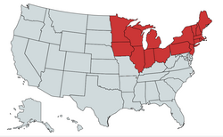
 Historically, especially in the time the American Civil War the states in red were known as "the North"; settlement expansion to the Pacific (upper left) extended the Northern United States all along the Canada–United States border | |
| Country | United States |
| States | Connecticut Illinois Indiana Iowa Maine Massachusetts Michigan Minnesota New Hampshire New Jersey New York Ohio Pennsylvania Rhode Island Vermont Wisconsin |
| Subregions | Northeastern United States Midwestern United States |
| Area | |
| • Total | 625,897.06 sq mi (1,621,065.9 km2) |
| • Land | 540,298.08 sq mi (1,399,365.6 km2) |
| Population | |
| • Total | 111,736,936 |
| • Density | 180/sq mi (69/km2) |
| Demonym | Northerner |
The Northern United States, commonly referred to as the American North, the Northern States, or simply the North, is a geographical and historical region of the United States.
- ^ "United States Summary: 2010, Population and Housing Unit Counts, 2010 Census of Population and Housing" (PDF). United States Census Bureau. September 2012. pp. V–2, 1 & 41 (Tables 1 & 18). Retrieved February 7, 2014.
- ^ "Annual Estimates of the Resident Population for the United States, Regions, States, District of Columbia, and Puerto Rico: April 1, 2020 to July 1, 2021". Retrieved December 20, 2023.
- ^ "Population, Population Change, and Estimated Components of Population Change: April 1, 2010 to July 1, 2019 (NST-EST2019-alldata)". Census.gov. United States Census Bureau. Archived from the original on January 26, 2020. Retrieved 8 February 2020.