Back مقاطعة دالاس (تكساس) Arabic Dallas (Texas dairəsi) AZ دالاس بؤلگهسی، تکزاس AZB Dallas County, Texas BAR Далас (акруга, Тэхас) BE Далас (окръг, Тексас) Bulgarian ডালাস কাউন্টি, টেক্সাস BPY Comtat de Dallas (Texas) Catalan Dallas Gông (Texas) CDO Dallas County (kondado sa Tinipong Bansa, Texas) CEB
Dallas County | |
|---|---|
From top, left to right: Dallas panorama, Dallas Hall in University Park, former Dallas County Courthouse with the Texas flag in 2017, Las Colinas in Irving | |
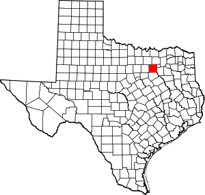
 Location within the U.S. state of Texas | |
 Texas's location within the U.S. | |
| Coordinates: 32°46′N 96°47′W / 32.77°N 96.78°W | |
| Country | |
| State | |
| Founded | March 30, 1846 |
| Named for | George M. Dallas |
| Seat | Dallas |
| Largest city | Dallas |
| Area | |
| • Total | 908.54 sq mi (2,353.1 km2) |
| • Land | 873.06 sq mi (2,261.2 km2) |
| • Water | 35.48 sq mi (91.9 km2) |
| Population (2020) | |
| • Total | 2,613,539 |
| • Density | 2,994/sq mi (1,156/km2) |
| Time zone | UTC−6 (Central) |
| • Summer (DST) | UTC−5 (CDT) |
| Congressional districts | 5th, 6th, 24th, 30th, 32nd, 33rd |
| Website | www |
Dallas County is the second-most populous county in the U.S. state of Texas with a 2020 U.S. census of 2,613,539,[1] making it the ninth-most populous county in the country. Dallas County is included in the Dallas-Arlington-Fort Worth metropolitan statistical area—colloquially referred to as the Dallas–Fort Worth metroplex. Municipal expansion within Dallas County has blurred the geographic lines between cities and between neighboring counties.[2]
Its county seat is the city of Dallas,[3] which is also Texas' third-largest city and the ninth-largest city in the United States. The county was founded in 1846 and was possibly named for George Mifflin Dallas, the 11th Vice President of the United States under U.S. President James K. Polk.
- ^ "QuickFacts: Dallas County, Texas". United States Census Bureau. Retrieved September 21, 2021.
- ^ Almon, Jan (2014). Dallas County: A 21st Century Mosaic (PDF). Photography by Mary Ann Sherman. HPNbooks. ISBN 978-1-939300-59-1. Archived (PDF) from the original on November 14, 2022.
- ^ "Find a County". National Association of Counties. Archived from the original on May 31, 2011. Retrieved June 7, 2011.


