Back Somerset AF Somerset AN Sumorsæte ANG مقاطعة سومرست (إنجلترا) Arabic سومرسيت ARZ Somerset AST Somerset AZ Somerset BAN Сомерсет BE Сомэрсэт BE-X-OLD
Somerset | |
|---|---|
 | |
| Coordinates: 51°06′N 2°54′W / 51.100°N 2.900°W | |
| Sovereign state | United Kingdom |
| Constituent country | England |
| Region | South West England |
| Established | Ancient |
| Time zone | UTC±00:00 (Greenwich Mean Time) |
| • Summer (DST) | UTC+01:00 (British Summer Time) |
| Members of Parliament |
|
| Police | Avon and Somerset Police |
| Ceremonial county | |
| Lord Lieutenant | Mohammed Saddiq |
| High Sheriff | Mary-Clare Rodwell[1] (2020–21) |
| Area | 4,171 km2 (1,610 sq mi) |
| • Ranked | 7th of 48 |
| Population (2021) | 965,424 |
| • Ranked | 22nd of 48 |
| Density | 232/km2 (600/sq mi) |
| Ethnicity | 98.5% White |
| Unitary authorities | |
| Councils | Somerset Council Bath and North East Somerset Council North Somerset Council |
| Districts | |
 Districts of Somerset Unitary | |
| Districts | |
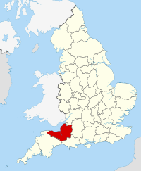
Somerset (/ˈsʌmərsɪt, -sɛt/ ⓘ SUM-ər-sit, -set;[2] archaically Somersetshire /ˈsʌmərsɪt.ʃɪər, -sɛt-, -ʃər/ SUM-ər-sit-sheer, -set-, -shər) is a ceremonial county in South West England. It is bordered by the Bristol Channel, Gloucestershire, and Bristol to the north, Wiltshire to the east and the north-east, Dorset to the south-east, and Devon to the south-west. The largest settlement is the city of Bath, and the county town is Taunton.
Somerset is a predominantly rural county, especially to the south and west, with an area of 4,171 km2 (1,610 sq mi) and a population of 965,424. After Bath (101,557), the largest settlements are Weston-super-Mare (82,418), Taunton (60,479), and Yeovil (49,698). Wells (12,000) is a city, the second-smallest by population in England. For local government purposes the county comprises three unitary authority areas: Bath and North East Somerset, North Somerset, and Somerset. Bath and North East Somerset Council is a member of the West of England Combined Authority.
The centre of Somerset is dominated by the Levels, a coastal plain and wetland. The north-east contains part of the Cotswolds uplands and all of the Mendip Hills, which are both national landscapes; the west contains the Quantock Hills and part of the Blackdown Hills, which are also national landscapes, and most of Exmoor, a national park. The major rivers of the county are the Avon, which flows through Bath and then Bristol, and the Axe, Brue, and Parrett, which drain the Levels.
There is evidence of Paleolithic human occupation in Somerset, and the area was subsequently settled by the Celts, Romans and Anglo-Saxons. The county played a significant part in Alfred the Great's rise to power, and later the English Civil War and the Monmouth Rebellion. In the later medieval period its wealth allowed its monasteries and parish churches to be rebuilt in grand style; Glastonbury Abbey was particularly important, and claimed to house the tomb of King Arthur and Guinevere. The city of Bath is famous for its Georgian architecture, and is a UNESCO World Heritage Site. The county is also the location of Glastonbury Festival, one of the UK's major music festivals.
- ^ "No. 62943". The London Gazette. 13 March 2020. p. 5161.
- ^ "Somerset definition and meaning". Collins English Dictionary. Archived from the original on 28 April 2021. Retrieved 29 May 2020.


