Back مقاطعة غوجيبيك (ميشيغان) Arabic Gogebic County, Michigan BAR Гогибик (окръг, Мичиган) Bulgarian গোজেবিক কাউন্টি, মিশিগান BPY Gogebic Gông (Michigan) CDO Gogebic County CEB Gogebic County Czech Gogebic County, Michigan CY Gogebic County German Kantono Gogebic EO
Gogebic County | |
|---|---|
 | |
 Location within the U.S. state of Michigan | |
 Michigan's location within the U.S. | |
| Coordinates: 46°29′N 89°47′W / 46.48°N 89.79°W | |
| Country | |
| State | |
| Founded | 1887[1] |
| Named for | Lake Gogebic |
| Seat | Bessemer |
| Largest city | Ironwood |
| Area | |
| • Total | 1,476 sq mi (3,820 km2) |
| • Land | 1,102 sq mi (2,850 km2) |
| • Water | 374 sq mi (970 km2) 25% |
| Population (2020) | |
| • Total | 14,380 |
| • Density | 15/sq mi (6/km2) |
| Time zone | UTC−6 (Central) |
| • Summer (DST) | UTC−5 (CDT) |
| Congressional district | 1st |
| Website | www |
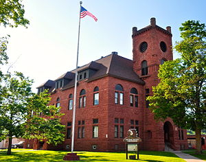
Gogebic County (/ɡoʊˈɡiːbɪk/ goh-GEE-bik or /ɡoʊˈɡɛbɪk/ goh-GEH-bik) is a county in the Upper Peninsula of the U.S. state of Michigan. As of the 2020 census, the population was 14,380.[2] The county seat is Bessemer.[3] Gogebic County is the westernmost county in Michigan, and is one of four Michigan counties within the Central Time Zone. Gogebic County borders Wisconsin to the south, and has a shoreline on Lake Superior to the north.
Gogebic County has long been territory of the Lake Superior Chippewa. The Lac Vieux Desert Indian Reservation is located within Gogebic County.
- ^ "Bibliography on Gogebic County". Clarke Historical Library, Central Michigan University. Retrieved June 29, 2013.
- ^ "State & County QuickFacts". US Census Bureau. Retrieved September 15, 2021.
- ^ "Find a County". National Association of Counties. Archived from the original on May 31, 2011. Retrieved June 7, 2011.
