| Thebarton Adelaide, South Australia | |||||||||||||||
|---|---|---|---|---|---|---|---|---|---|---|---|---|---|---|---|
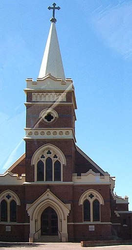
 Queen of Angels Roman Catholic church on the corner of South Road and Kintore Street | |||||||||||||||
| Population | 1,442 (SAL 2021)[1] | ||||||||||||||
| Established | 1839[2] | ||||||||||||||
| Postcode(s) | 5031[3] | ||||||||||||||
| Location | 2 km (1 mi) W of Adelaide | ||||||||||||||
| LGA(s) | City of West Torrens | ||||||||||||||
| State electorate(s) | West Torrens | ||||||||||||||
| Federal division(s) | Adelaide | ||||||||||||||
| |||||||||||||||
Thebarton (/ˈθɛbərtən/ THEB-ər-tən), formerly Theberton, on Kaurna land, is an inner-western suburb of Adelaide, South Australia in the City of West Torrens. The suburb is bounded by the River Torrens to the north, Port Road and Bonython Park to the east, Kintore Street to the south, and South Road to the west.
Many buildings and landmarks that bear the name of Thebarton were in the history municipality, the Town of Thebarton, which included most of the adjoining suburb of Torrensville. These include the Thebarton Oval, the Thebarton croquet and bowls club, Thebarton Theatre, and Thebarton Senior College. The historic Adelaide Gaol, nominally shown as being in Thebarton, and the adjacent Thebarton Barracks of the South Australia Police actually lie within the northwestern Adelaide Park Lands. A part of Thebarton adjacent to the River Torrens, later the site of the South Australian Brewing Company, was originally known as Southwark. Hemmington, Hemmington West and West Thebarton were also suburbs later incorporated into current-day Thebarton.
- ^ Australian Bureau of Statistics (28 June 2022). "Thebarton (suburb and locality)". Australian Census 2021 QuickStats. Retrieved 28 June 2022.
- ^ Place names of South Australia The Manning Index of South Australian History. State Library of South Australia. Retrieved 28 April 2014.
- ^ Australia Post - Postcode:Thebarton, SA (28 April 2014)
