Back جبل جوادالوپ پياك ARZ Guadalupe Peak (bukid sa Tinipong Bansa, Texas) CEB Guadalupe Peak Czech Guadalupe Peak German Pico Guadalupe Spanish کوه گوادالوپ FA Pic Guadalupe French Guadalupe Peak Italian Guadalupe Peak LLD Guadalupe Peak Dutch
| Guadalupe Peak | |
|---|---|
 | |
| Highest point | |
| Elevation | 8,751 ft (2,667 m) NAVD 88[1] |
| Prominence | 3,029 ft (923 m)[2] |
| Listing | State high point 14th |
| Coordinates | 31°53′29″N 104°51′39″W / 31.891460742°N 104.860710292°W[1] |
| Geography | |
| Location | Culberson County, Texas, U.S. |
| Parent range | Guadalupe Mountains |
| Topo map | USGS Guadalupe Peak |
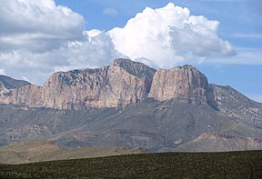
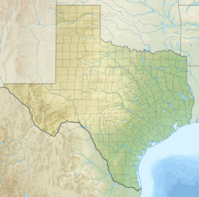
Guadalupe Peak, also known as Signal Peak,[3] is the highest natural point in Texas,[4] with an elevation of 8,751 feet (2,667 m) above sea level.[1] It is located in Guadalupe Mountains National Park, and is part of the Guadalupe Mountains range in southeastern New Mexico and West Texas. The mountain is about 90 miles (140 km) east of El Paso and about 50 miles (80 km) southwest of Carlsbad, New Mexico. The peak rises more than 3,000 feet (910 m) above the arid floor of the Chihuahuan Desert.
- ^ a b c "El Capitan". NGS Data Sheet. National Geodetic Survey, National Oceanic and Atmospheric Administration, United States Department of Commerce. Retrieved 2001-05-24.
- ^ "Guadalupe Peak, Texas". Peakbagger.com. Retrieved 2001-05-24.
- ^ "GUADALUPE PEAK". Handbook of Texas Online. Texas State Historical Association. 15 June 2010. Retrieved 7 April 2015.
- ^ "Elevations and Distances in the United States". United States Geological Survey. April 29, 2005. Archived from the original on January 16, 2008. Retrieved 2009-03-28.
