Back مقاطعة ميامي (أوهايو) Arabic Miami County, Ohio BAR Маями (окръг, Охайо) Bulgarian মায়ামি কাউন্টি, ওহাইও BPY Miami Gông (Ohio) CDO Miami County (kondado sa Tinipong Bansa, Ohio) CEB Miami County, Ohio CY Miami County (Ohio) Danish Miami County (Ohio) German Condado de Miami (Ohio) Spanish
Miami County | |
|---|---|
 County courthouse in Troy | |
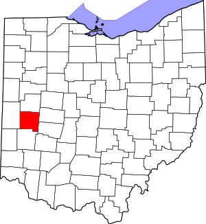
 Location within the U.S. state of Ohio | |
 Ohio's location within the U.S. | |
| Coordinates: 40°03′N 84°14′W / 40.05°N 84.23°W | |
| Country | |
| State | |
| Founded | March 1, 1807[1] |
| Named for | Miami people |
| Seat | Troy |
| Largest city | Troy* |
| Area | |
| • Total | 410 sq mi (1,100 km2) |
| • Land | 407 sq mi (1,050 km2) |
| • Water | 3.1 sq mi (8 km2) 0.8% |
| Population (2020) | |
| • Total | 108,774 |
| • Density | 270/sq mi (100/km2) |
| Time zone | UTC−5 (Eastern) |
| • Summer (DST) | UTC−4 (EDT) |
| Congressional districts | 8th, 15th |
| Website | www |
Miami County is a county located in the U.S. state of Ohio. As of the 2020 census, the population was 108,774.[2] Its county seat is Troy.[3] The county is named in honor of the Miami people.[4]
Miami County is part of the Dayton, OH Metropolitan Statistical Area.
- ^ "Ohio County Profiles: Miami County" (PDF). Ohio Department of Development. Archived from the original (PDF) on June 21, 2007. Retrieved April 28, 2007.
- ^ 2020 census
- ^ "Find a County". National Association of Counties. Archived from the original on May 31, 2011. Retrieved June 7, 2011.
- ^ "Miami County". Ohio History Central. Retrieved March 18, 2020.
