Back ستيمبوت سبرينغز (كولورادو) Arabic ستيمبوت سبرينجز ARZ Стиймбоут Спрингс Bulgarian Steamboat Springs Catalan Стимбоут-Спрингс (Колорадо) CE Steamboat Springs (kapital sa kondado) CEB Steamboat Springs, Colorado CY Steamboat Springs (Colorado) German Steamboat Springs Spanish Steamboat Springs (Colorado) EU
Steamboat Springs, Colorado | |
|---|---|
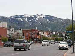
 Downtown Steamboat Springs in May 2006 with the ski area in the background | |
| Nickname: Ski Town USA | |
 Location of the City of Steamboat Springs in Routt County, Colorado | |
Location of the City of Steamboat Springs in the United States | |
| Coordinates: 40°30′17″N 106°49′36″W / 40.50472°N 106.82667°W | |
| Country | |
| State | |
| County | Routt County[2] |
| City | Steamboat Springs[1] |
| Incorporated | July 19, 1900[3] |
| Government | |
| • Type | Home rule municipality[1] |
| Area | |
| • Total | 9.90 sq mi (25.64 km2) |
| • Land | 9.89 sq mi (25.61 km2) |
| • Water | 0.01 sq mi (0.03 km2) |
| Elevation | 6,867 ft (2,093 m) |
| Population | |
| • Total | 13,224 |
| • Density | 1,300/sq mi (520/km2) |
| Time zone | UTC−7 (MST) |
| • Summer (DST) | UTC−6 (MDT) |
| ZIP Codes[7] | 80477, 80487, 80488 |
| Area code | 970 |
| FIPS code | 08-73825 |
| GNIS feature ID | 2411976[5] |
| Website | City Website |
Steamboat Springs is a home rule municipality that is the county seat and the most populous municipality of Routt County, Colorado.[8] The population was 13,224 at the 2020 census.[9] Steamboat Springs is the principal city of the Steamboat Springs Micropolitan Statistical Area, and it is the largest city in northwestern Colorado.
The city is a winter ski resort destination, including the Steamboat Ski Resort on Mount Werner in the Park Range just east of the town and the much smaller Howelsen Hill Ski Area. Steamboat Springs has produced more athletes for the Winter Olympics than any other town in North America.[10]
Steamboat Springs – known colloquially as "The Boat" – is located in the upper valley of the Yampa River, along U.S. Highway 40, just west of the Continental Divide and Rabbit Ears Pass. It is located approximately 150 miles northwest of Denver, and sits approximately 45 miles south of the Wyoming border.[11] It is served by Steamboat Springs Airport (general aviation) and commercial service at nearby Yampa Valley Airport.
- ^ a b c "Active Colorado Municipalities". State of Colorado, Colorado Department of Local Affairs, Division of Local Government. Retrieved January 27, 2021.
- ^ "Colorado Counties". State of Colorado, Colorado Department of Local Affairs, Division of Local Government. Retrieved January 27, 2021.
- ^ "Colorado Municipal Incorporations". State of Colorado, Department of Personnel & Administration, Colorado State Archives. December 1, 2004. Retrieved September 2, 2007.
- ^ "2019 U.S. Gazetteer Files". United States Census Bureau. Retrieved July 1, 2020.
- ^ a b U.S. Geological Survey Geographic Names Information System: Steamboat Springs, Colorado
- ^ "Explore Census Data". U.S. Census Bureau. Retrieved March 1, 2022.
- ^ "ZIP Code Lookup". United States Postal Service. Archived from the original (JavaScript/HTML) on November 4, 2010. Retrieved January 4, 2008.
- ^ "Find a County". National Association of Counties. Retrieved June 7, 2011.
- ^ United States Census Bureau. "Steamboat Springs city; Colorado". Retrieved April 20, 2023.
- ^ "The secret to Steamboat's Olympic success". Coloradoan. Retrieved April 2, 2020.
- ^ "Denver to Steamboat Springs". Denver to Steamboat Springs. Retrieved April 3, 2021.


