Back Lincoln, Nebraska AF Lincoln (Nebraska) AN Lincoln (Gnebrāsca) ANG لنكن (نبراسكا) Arabic لينكون (نبراسكا) ARZ Lincoln (Nebraska) AST Linkoln (Nebraska) AZ لینکلن، نبراسکا AZB Linkolns BAT-SMG Лінкальн (Небраска) BE
Lincoln | |
|---|---|
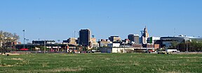
Downtown Lincoln skyline | |
| Nickname: Star City[1] | |
 Location within Lancaster County | |
| Coordinates: 40°48′33″N 96°40′41″W / 40.80917°N 96.67806°W | |
| Country | |
| State | |
| County | Lancaster |
| Founded | 1856 (Lancaster) |
| Renamed | July 29, 1869 (Lincoln) |
| Incorporated | April 1, 1869 |
| Named for | Abraham Lincoln |
| Government | |
| • Type | Strong mayor–council |
| • Mayor | Leirion Gaylor Baird (D) |
| • City council | Members |
| • U.S. Congress | Mike Flood (R) |
| Area | |
| • State capital city | 100.45 sq mi (260.16 km2) |
| • Land | 99.09 sq mi (256.63 km2) |
| • Water | 1.36 sq mi (3.52 km2) 1.4% |
| • Urban | 94.17 sq mi (243.9 km2) |
| • Metro | 1,422.269 sq mi (3,683.660 km2) |
| • CSA | 2,282.229 sq mi (5,910.95 km2) |
| Elevation | 1,201 ft (366 m) |
| Population (2020) | |
| • State capital city | 291,082 |
| • Density | 2,937.67/sq mi (1,134.24/km2) |
| • Urban | 291,217 (US: 139th) |
| • Urban density | 3,092.3/sq mi (1,193.9/km2) |
| • Metro | 342,117 (US: 152nd) |
| • Metro density | 240.5/sq mi (92.9/km2) |
| • CSA | 363,733 (US: 104th) |
| • CSA density | 159.4/sq mi (61.5/km2) |
| Demonym | Lincolnite |
| Time zone | UTC−6 (CST) |
| • Summer (DST) | UTC−5 (CDT) |
| ZIP code(s) | 68501-68510, 68512, 68514, 68516-68517, 68520-68524, 68526-68529, 68531, 68542, 68544, 68583, 68588 |
| Area codes | 402, 531 |
| FIPS code | 31-28000 |
| GNIS feature ID | 837279[3] |
| Website | lincoln.ne.gov |
| α. ^ 1 2 Area, city density, metro population/density and CSA population/density as of the 2021 estimate.[4][5] β. ^ Urban population/density as of the 2020 Census.[6] | |
Lincoln is the capital city of the U.S. state of Nebraska and the county seat of Lancaster County. The city covers 100.4 square miles (260.035 km2) with a population of 292,657 in 2021. It is the state's 2nd most populous city and the 73rd-largest in the United States. Lincoln is the economic and cultural anchor of a substantially larger metropolitan area in southeastern Nebraska, the Lincoln Metropolitan and Lincoln-Beatrice Combined Statistical Areas. The statistical area is home to 361,921 people, making it the 104th-largest combined statistical area in the United States.
Lincoln was founded in 1856 as the village of Lancaster on the wild salt marshes and arroyos of what became Lancaster County. Renamed after President Abraham Lincoln, it became Nebraska's state capital in 1869. The Bertram G. Goodhue–designed state capitol building was completed in 1932, and is the nation's second-tallest capitol. As the city is the seat of government for the state of Nebraska, the state and the U.S. government are major employers. The University of Nebraska was founded in Lincoln in 1869. The university is Nebraska's largest, with 26,079 students enrolled, and the city's third-largest employer. Other primary employers fall into the service and manufacturing industries, including a growing high-tech sector. The region makes up a part of what is known as the greater Midwest Silicon Prairie.
Designated as a "refugee-friendly" city by the U.S. Department of State in the 1970s, the city was the 12th-largest resettlement site per capita in the country by 2000. Refugee Vietnamese, Karen (Burmese ethnic minority), Sudanese and Yazidi (Iraqi ethnic minority) people, as well as refugees from Iraq, the Middle East and Afghanistan, have resettled in the city. During the 2018–19 school year, Lincoln Public Schools provided support for about 3,000 students from 150 countries, who spoke 125 different languages.
- ^ "Campus Guide: Lincoln lexicon". Lincoln Journal Star. Lincoln, NE. August 22, 2011. Retrieved August 18, 2016.
- ^ "ArcGIS REST Services Directory". United States Census Bureau. Retrieved September 18, 2022.
- ^ a b "Geographic Names Information System". edits.nationalmap.gov. Retrieved May 8, 2023.
- ^ "Metropolitan and Micropolitan Statistical Areas Population Totals and Components of Change: 2020-2021 -- Annual Resident Population Estimates and Estimated Components of Resident Population Change for Combined Statistical Areas and Their Geographic Components: April 1, 2020 to July 1, 2021 (CSA-EST2021-ALLDATA)". U.S. Census Bureau. U.S. Department of Commerce. July 1, 2021. Retrieved July 11, 2022.
- ^ "Annual Estimates of the Resident Population in the United States and Puerto Rico: April 1, 2020 to July 1, 2021 -- Metropolitan Statistical Area; and for Puerto Rico (CBSA-MET-EST2021-POP)". U.S. Census Bureau. U.S. Department of Commerce. July 1, 2021. Retrieved July 11, 2022.
- ^ "List of 2020 Census Urban Areas". United States Census Bureau. Retrieved January 2, 2023.


